Registering Natural Regeneration in the ETS
Learn what it takes to successfully register forest land into the ETS with our expert Carbon Forestry Consultant, Narendra Chand.
Background
In order to successfully register a naturally regenerated native forest into the Emissions Trading Scheme (ETS), substantial evidence is required.
The evidence submitted at the application stage is vital to the outcome of successful registration. The natural regeneration cases are much different to planting cases which are more simplistic and easier to prove eligible. In the natural regeneration cases, it must show that the regenerating indigenous species are eligible tree species, abundant enough to meet 30% canopy cover per hectare at maturity, and that it was regenerated after December 31st 1989.
At Ekos we typically suggest a vegetation assessment for any naturally regenerating native blocks. This includes on the ground data collection at systematically allocated sample points and in some cases, where needed, includes destructive sampling to detect the age of trees.
We have found that our methodology and reporting has worked extremely well in getting approval from MPI for the natural regeneration cases. To date, Ekos has successfully registered 883 hectares of forest into the ETS and have a further 335 hectares submitted and awaiting approval from MPI. Out of this, we have successfully registered 325.4 hectares of natural regeneration and have 170.2 hectares of natural regeneration forest awaiting approval from MPI, that has used the same methods, the vegetation assessment.
When you rely on aerial imagery as your evidence towards a natural regenerating native forest, MPI may not find that evidence sufficient, particularly for the younger regenerating forests. Here are the reasons why:
Aerial imagery cannot pick up stocking of tree species present. Taking data in the field can provide real stocking numbers to ensure 30% canopy cover per hectare can be met at maturity.
Younger natural regeneration can be hiding under gorse and hence not visible by aerial imagery.
In some cases, it can be too difficult to distinguish the age of a naturally regenerating forest by aerial imagery due to availability of imagery around 1990. Therefore why, destructive sampling can be a great way to estimate the forests' age.
Case Study: Kotuku Bushby, West Coast
The Kotuku site is one of Meridian Energy's’ Forever Forest Projects, part of their Forever Forest Programme. Prior to Meridian purchasing this site, it was occupied with exotic forest and harvested in 2013 & 2014. It has very good access—a public road on two sides and a good track through the centre, easy topography, and an ideal aspect for carbon farming. Following the harvesting of the exotic forest, the site was invaded with gorse. However, some remnants of pre-1990 Indigenous tree species were on the site. Those remnants of forests worked as seed sources. The presence of native forest patches nearby is significant for diverse and abundant seedling establishment.
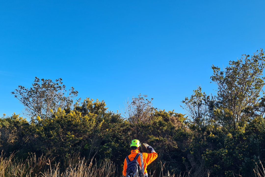
The journey of doing vegetation assessment was thrilling and will remain unforgettable. I designed a vegetation assessment methodology based on a 2015-16 aerial photograph that was the latest available. From the aerial photograph, the site looked like grassland and was accessible. My first attempt to do the vegetation assessment was in 2022. I went to the site with two other colleagues, but when I entered the site, the site was different. It was full of gorse and waterlogged everywhere (Figure 1 & 2); there was rain the day before my assessment. I tried to reach the waypoints from the different corners of the site I designed for the assessment, but I was hardly successful in reaching those waypoints. After a day of trying to reach the single waypoint, our team called off the assessment.
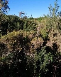
Figure 1. Gorse at site

Figure 2. Gorse at site
We revisited the site with Sean Weaver, the CEO of Ekos Kamahi Limited, to assess it and determine whether native tree species exist to comply with the NZETS requirement and to decide alternative approach to assess the site. After visiting that site, we found plenty of native tree species growing under the gorse (Figure 3 & 4), so we decided to conduct a vegetation assessment again and use a portable chainsaw to gain access through the gorse.
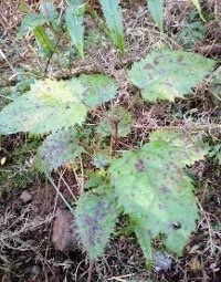
Figure 3. Wineberry regeneration

Figure 4. Wineberry regeneration
I allocated 148 waypoints systematically and went to the site with another colleague who is skilled at running a power chain saw. This was my third attempt to conduct a vegetation assessment. We reached the first waypoint, cutting the gorse to the waypoints according to our plan. It took us almost 1 hour to reach the WP; we became very scratched up and exhausted. We assessed the native tree species on the WP. To go to the next WP, we had to get out of the first WP, but even though we had a GPS device, we were completely exhausted using a power chain saw and making a way to get out. We attempted to assess more sample points, but it was impossible to assess systematically allocated WP on the site full of gorse. We returned to the hotel and decided to redesign the sampling plan, which is statically correct and acceptable to the Ministry for Primary Industries.
Altogether, 268 waypoints were planned for the property. However, due to further inaccessibility challenges, only 163 waypoints were measured near newly formed tracks at the site. The waypoints were laid down at 10 m from the tracks. Based on the assessment of 163 WP, I prepared a vegetation assessment report, and 115 ha of forest area was submitted to the MPI for registration under NZETS. Other supporting documents, such as vegetation photographs of WPs and drone imagery, were also provided to the MPI. Recently, MPI informed us that the entire 115 ha of regenerating land is approved and registered under the NZETS. Figure 5 & 6 show some of the photographs taken at the WPs.

Figure 5. Natural regeneration

Figure 6. Natural regeneration
This exercise demonstrated that even though the vegetation assessment requires much effort and cost, it provides strong evidence for registering naturally regenerating land when natural regeneration is not visible on aerial imagery or if the age of the forest cannot be determined by aerial imagery.